


4.5 out of 5

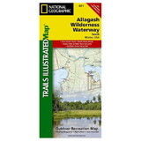
National Geographic 603254 Allagash Wilderness Waterway North No.400
* Click "Add to Cart" to calculate shipping and delivery time.
Product Description
The Allagash Wilderness Waterway is a majestic 92-mile-long ribbon of rivers, lakes, ponds, and streams that winds its way through the heart of the North Maine Woods. National Geographic's Trails Illustrated map of Allagash Wilderness Waterway North is designed to meet the needs of outdoor enthusiasts by combining valuable information with unmatched detail of this popular recreation area. Created in partnership with local land management agencies, this expertly researched map features key areas of interest including Fort Kent State, Saint John River, Saint Froid Lake, Round Pond, Allagash River, Umsaskis Lake, Fish River, Long Lake, Debouille Ecological Reserve, and the Musquacook lakes.
The map base includes contour lines, shaded relief, and elevations for summits and many lakes. Recreation features are clearly marked, including picnic areas, trailheads, RV camping, primitive campsites, canoe carry downs, and boat launches. This map is loaded with valuable information such as watercraft regulations, rules for recreational use and access, river difficulty scale, checkpoints, visitor and ranger station locations, and more.
Other features found on this map include: Allagash River, Eagle Lake.
 Attention CA Residents: Prop 65 Warning
WARNING:
This product can expose you to chemicals which are known to the State of California to cause cancer, birth defects, or other reproductive harm. For more information, go to www.p65warnings.ca.gov.
Need more information?
Our staff are available to answer any questions you may have about this item
Our staff are available to answer any questions you may have about this item
Customer Reviews
By A Customer
Date: May 30, 2017
Given the map is of the 34;Allagash River Waterway34;, I found it intriguing that it was blown up to the point where there was a requirement to purchase two separate maps. The sheer size of each required constant adjustment if one used a waterproof case (which is common on a canoeing trip) in order to prove useful during the day. I would have happily paid more for a more appropriately sized map as the map quality was good, accurate and extremely useful.
Rating:  [2 of 5 Stars!]
[2 of 5 Stars!]
By A Customer
Date: October 21, 2016
Thank you
Rating:  [5 of 5 Stars!]
[5 of 5 Stars!]
By Emmanuel S Boss
Date: August 14, 2016
Loved the maps and used them in the field.
Rating: [5 of 5 Stars!]
[5 of 5 Stars!]
By Arthur Payeur
Date: August 11, 2016
Nice map showed me what I needed and it is water proof... which is important on a canoe trip
Rating: [5 of 5 Stars!]
[5 of 5 Stars!]
Items 1 - 4 of 4 reviews
1