


4.5 out of 5

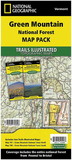
National Geographic 603207 Green Mountain National Forest North No.747
* Click "Add to Cart" to calculate shipping and delivery time.
Product Description
The Green Mountain National Forest encompasses more than 400,000 acres in southwestern and central Vermont, forming the largest contiguous public land area in the state. National Geographic's Trails Illustrated map of Green Mountain National Forest North combines unmatched detail with helpful information to offer an invaluable tool for making the most of your visit to this beautiful region. Expertly researched and created in partnership with local land management agencies, this map features key points of interest including Moosalamoo National Recreation Area; Branbury, Bomoseen, Ainsworth, Allis, Granville Reservation, and Silver Lake state parks; Killington, Pico Mountain, and Sugarbush ski areas; Chittenden Reservoir; Bristol Cliffs, Breadloaf, and Joseph Battel wilderness areas; and portions of the White, Connecticut, and Ottauquechee rivers.
The map base includes contour lines and elevations for summits, passes and many lakes. Many recreation features are noted as well, including interpretive trails, campgrounds, swimming areas, boat launches, waterfalls, shooting ranges, fishing areas, and covered bridges.
Other features found on this map include: Blueberry Mountain, Braintree Mountain, Breadloaf Wilderness, Broad Brook Mountain, Green Mountain National Forest, Hanover, Hartford, Joseph Battell Wilderness, Killington Peak, Lake Bomoseen, Lincoln Mountain, Mount Moosalamoo, Northfield Mountains, Pico Peak, Rutland, White River.
 Attention CA Residents: Prop 65 Warning
WARNING:
This product can expose you to chemicals which are known to the State of California to cause cancer, birth defects, or other reproductive harm. For more information, go to www.p65warnings.ca.gov.
Need more information?
Our staff are available to answer any questions you may have about this item
Our staff are available to answer any questions you may have about this item
Customer Reviews
By Lonebadger
Date: January 16, 2018
Poor distance references on trails compared to the NY series; but that may just be a Vermont thing.
Rating:  [3 of 5 Stars!]
[3 of 5 Stars!]
By Barbara Jeanne
Date: February 20, 2017
Excellent series of maps including topographical lines
Rating:  [5 of 5 Stars!]
[5 of 5 Stars!]
By Dennis D
Date: October 18, 2016
Nice water proof map. Excellent
Rating: [5 of 5 Stars!]
[5 of 5 Stars!]
Items 1 - 3 of 3 reviews
1